Tag Archives: hiking

Pike o’Stickle and Bowfell

Tuesday 21st June 2016, 12.05pm (day 1,762)

Pike o'Stickle and Bowfell, 21/6/16

After over a week of it raining every day, today — the summer solstice — while not exactly sunny, was at least dry. I had a book needing reading for work, I took it on the trains and went for a short but rewarding walk around the head of Great Langdale. Bowfell, in the background, is 2,960 feet high, and not on the itinerary today, but I did get to the sugarloaf summit of Pike o’Stickle about half an hour after this picture was taken. Note the walkers on the top at this point.

Tagged , , , , , , , , , , , ,

Climbing Blencathra

Monday 23rd May 2016, 12 noon (day 1,733)

Climbing Blencathra, 23/5/16

My weekend was Sunday and today. I still seem willing to get up to the Lake District when I can — it’s been six weeks since my last visit, I was getting itchy. Probably I’ll still be doing it when I’m this guy’s age. After all, with a backdrop like this for one’s life — how can it be wrong? The lake is Derwent Water, the town Keswick, the mountains are all worth the time, if I haven’t convinced you yet to visit this part of the world then you really haven’t been paying attention. (See my other blog for the details of today’s walk, and all the rest of them too.)

Tagged , , , , , , , , , ,

Great Gable and Kirk Fell

Monday 28th March 2016, 1.30pm (day 1,677)

Great Gable and Kirk Fell, 28/3/16

As its name suggests, Great Gable is the pyramid on the left, and one of the most well-known fells in the Lake District and/or England. Last time I went up it was in foul weather (on 29/7/12) and I am determined to return to it in blue skies, so it was not on my itinerary today — but it was the best looking object on my walk round the upper reaches of the valleys of Borrowdale and Gillercomb. Colder and greyer than it might have been, but I quite like this shot, taken from the nearby summit of Brandreth.

Tagged , , , , , , , , , , , ,

Dale Head summit

Monday 7th March 2016, 1.45pm (day 1,656)

Dale Head summit, 7/3/16

Some weather forecasts just sit there demanding to be used. The thin veneer of vapour on the horizon is the nearest I got to clouds all day. The summit is Dale Head, between Newlands and Honister in the Lake District — a genuinely impressive cairn, and a damn fine view. This is why I worked yesterday instead.

Tagged , , , , , , , ,

Graystones and Wythop Moss, from Ling Fell

Thursday 18th February 2016, 12.20pm (day 1,638)

Graystones & Wythop Moss, 18/2/16

Graystones is the modest peak to centre right, Wythop Moss the substantial swamp below. The fringe of trees is the top end of Darling How plantation, which extends down into the unseen valley over the far side of the ridge. And yes, I took the day off, well, most of it anyway, to go on a walk. But I’m working Sunday, so these things balance out, before you call the employment police (probably the Tories are considering such a step).

Tagged , , , , , , , ,

Heron Pike

Friday 15th January 2016, 11.40am (day 1,604)

Spindrift and Windermere, 15/1/16

I remain grateful for the fact that I have a job flexible enough to allow me to bring my weekend forward a day and get out on a walk on a Friday. However, I wasn’t out basking in the sunshine or anything. This was a severe-weather walk, as rough as anything I’ve ever done, as evidenced by the spindrift seen here. Heron Pike sits between the lakes of Grasmere, Rydal Water and (pictured) Windermere. More photos from this walk on my other blog when I get round to it, but that’ll be tomorrow now.

Tagged , , , , , , , , ,

Bucks and does

Tuesday 13th October 2015, 11.35am (day 1,510)

Bucks and does, 13/10/15

I’m sure there are lots of things that could be better about this picture, but hey, it ain’t easy to capture wild red deer in England — there really aren’t very many of them, and they really don’t like people. This was my best attempt. I like the way the two bucks are clearly keeping an eye out for anyone who might be messin’ with their does, so to speak.

Tagged , , , , , , , , ,

The roof of Africa

Sunday 2nd August 2015, 6.40am (day 1,438)

Roof of Africa, 2/8/15

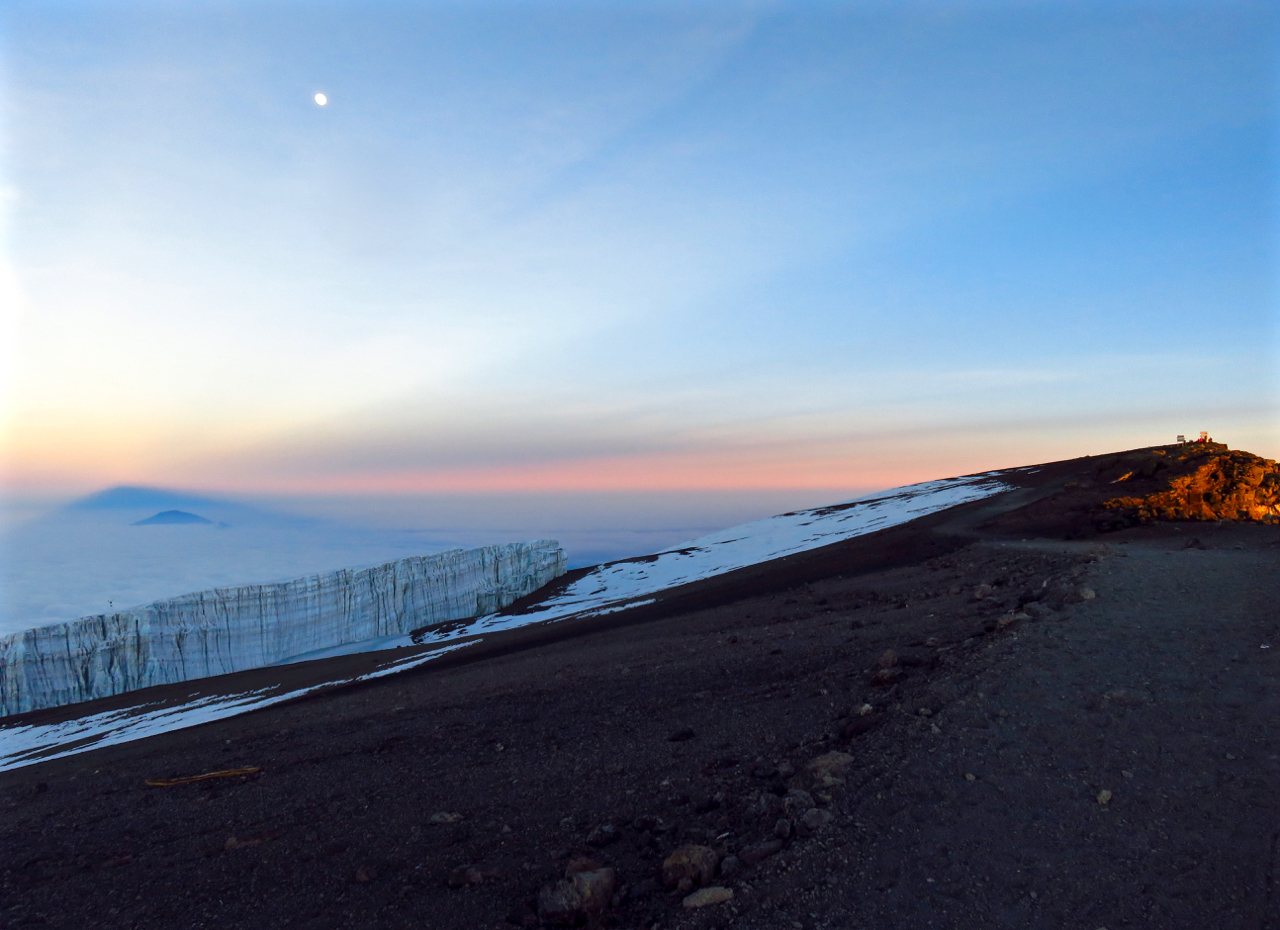
So here it is, the culmination of this walk, the highest point in Africa and the highest free-standing mountain in the world, Uhuru Peak, the summit of Kilimanjaro (5,895m or 19,341 feet above sea level).

You were getting a photo of it for today even if it had been as flat and featureless as a bowling green, but in all honesty this was the most beautiful, spectacular summit of any mountain I have ever visited. Believe me though, the effort it took to get here was intense. I don’t mean the five days of walking which had proceeded it which — if one can avoid altitude sickness (and I did) was not all that difficult — but the final climb up the ash slopes of Kibo, done between about 11.30pm and 6am, because during the hours of daylight it would be a) too hot and sunny and b) next-to-impossible anyway because one needs the ash to be semi-frozen in order to have a chance of ascending it. I had heard reports of people saying that one took about three steps up and then had to rest for about twenty seconds before having a chance of moving on, and dismissed them as exaggeration, but I can assure you they are not. That is really what it was like.

But once up there… time it right and one is there at sunrise. The light gradually reveals a wondrous landscape of delights, all over three-and-a-half miles up in the air. Here, the summit itself is on the far right of the picture, just caught by the sun which has also (I love this) projected a shadow of the whole summit cone onto the far horizon, neatly laid over Mount Meru, Tanzania’s second-highest peak, which at 4,565m or nearly 15,000 feet is no dwarf but from here is quite overshadowed (literally) by Kili. On the left is one of the mountain’s remaining glaciers, although don’t expect it to be around for much longer as within ten to fifteen years the ‘Snows of Kilimanjaro’ reported by Hemingway will most likely be gone — maps and pictures that show the whole summit area as covered in ice are now obsolete. Still, it’s a landform I’ve never been so close to before, and added an unearthly, or at least an un-African, element to the scene. The full moon above, which had illuminated our climb, is just the final touch.

What a place. Will I be back? Who knows, perhaps. I probably would do it again. If you do get the chance, and fancy putting in the work, I highly recommend it.

Tagged , , , , , , , , , ,

Steve at Barafu Camp

Saturday 1st August 2015, 6.10pm (day 1,437)

Steve at Barafu camp, 1/8/15

Barafu camp lies at 4,600m, or about 15,100 feet, and is ‘base camp’ for the final ascent to the summit of Kili, which rises behind this point. One arrives there around lunchtime and is supposed to get some sleep in the afternoon and evening because the final climb is done overnight. But the views are amazing, and I was not the only one defying advice and being up and about later on as the sun went down behind the shoulder of Kibo (and what must be one of the world’s most spectacularly-sited toilets, visible to the right).

Tagged , , , , , , ,

The porters, and Kibo

Thursday 30th July 2015, 9.25am (day 1,435)

Porters and Kibo, 30/7/15

In no way was this climb of Kilimanjaro a solo effort, and I mean that beyond just the fact I went up as part of a group of walkers. We had four guides, then also a team of porters, who took most of our luggage up the mountain, not to mention the tents, cooking equipment and other such gear. These guys (and occasionally girls — saw two or three female porters during the week) put in an astonishing amount of work and without them the climb would not have been possible for us. Here, some of them are pictured on day 3, which was one of only two fully sunny days during the week. Kibo, the main peak of the Kili massif, is in the background — getting closer… We approached it today through this Mars-like landscape.

Tagged , , , , , ,