The Firth of Tay makes a second appearance in a row, though this time, it (rather than a train) is the focus. The tide is definitely out. Taken from the top of Dundee Law, on what has become the mandated Post-Present Christmas Day Walk, as there often isn’t a great deal else to do on the day except the eating, drinking and watching movies part — which did follow. A Happy Christmas to you, wherever you may be and however you spent it.
Only in Britain do we really try to create seaside resorts on north-facing coasts at latitudes like 56º above the equator: but Redcar, near Middlesbrough, just about gets away with it thanks to having a really excellent beach that stretches for miles. Even when the sun is out, though, you still need to be quite hardy to make a day of it, but obviously this family have the necessary genetic qualities.
Now that’s a change of scene: from thatched cottages to a desert island. It’s nearly a year since my research funding award and, consequently, my chance to visit Ascension Island, were confirmed, and 73 days since I uploaded the map of this place to the blog. Zoom into that image and look at the westernmost headland of the island, where you can just about see the label ‘Tanks’: those are what you see in the distance.
St Helena doesn’t have beaches, and the tourist industry of that island may well lament this fact. But Dead Man’s Beach is a stupendous swathe of sand, and right by the main settlement, Georgetown. What a marvellously evocative name it has (though it will be explained not by the shipwreck of some 17th century pirate vessel, but because Georgetown’s cemetery lies right behind it). This is not even to mention the turtles, evidence for whom lies everywhere: but they will, hopefully, be pictured on one of the remaining eight evenings that I am scheduled to spend in the middle of the Atlantic.
In 1960 the population of Dubai was 40,000. As of today it is more than 3.7 million, and continuing to rise at around 5% a year (all figures from Wikipedia). In order to accommodate them, the city is also growing physically. What you see here is not ‘desert’, it is large amounts of sand that have been poured into the Persian Gulf — land ‘reclaimed’ because the sea is not a form of terrain that can be bought and sold. Go to Google Maps and search for “Dubai Island Villas”; you’ll find it just offshore from the Al Hamriya Port, and you’re looking at a photograph of it, as of 24th February 2025.
Captured, perhaps obviously, a minute or so after take-off from DXB this afternoon. I was sat right over a wing again and only got this because of the plane’s considerable roll to the right for a few moments, so this was the last I saw of anything except clouds for the next seven hours. That’s the end of this trip, then, but it seems reasonably likely I will be back in Dubai at some point over the next 2-3 years. It will be interesting (but perhaps also a little depressing) to see what this view might look like in 2028, say.
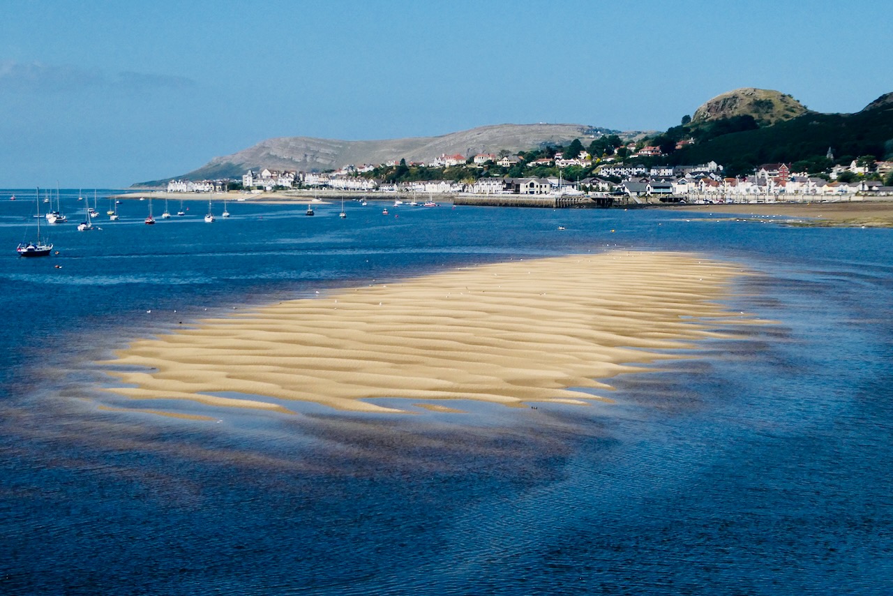
As no one really gives a toss whether I turn up at the office or not — particularly not in August — why not take the opportunity to get on a train, do a few hours’ work on the day, but still then take the afternoon off and spend it somewhere nice and sunny? The Conwy/Llandudno region is a fine-looking part of the world (as we discovered when we came here eight years ago). These kinds of regular Days Out are probably what it will take to keep me going for the rest of my life, spiritually — so let’s take the chances while they still come. And when the trains are working.
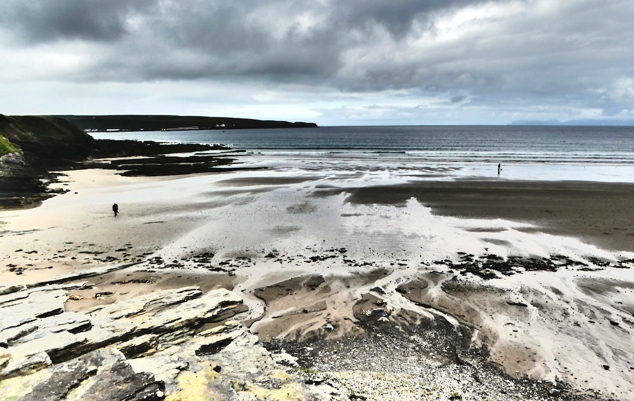
I have yet to start bringing my own deckchairs to beaches, and Clare and I remain, hopefully, more active than this — we reached Shanklin beach today, on the east coast of the Isle of Wight, after a 7.75 mile walk that you can read more about on my other blog. But in spirit, here we are. Give us ten years — maybe fifteen — and our bodies may be here too.
More desert, this time from above, the second of my internal Namibian flights, to Swakopmund on the coast (of which more tomorrow). The shapes here are just amazing, like the earth itself is crinkled, akin to the skin of a passion fruit, say. Quite probably, no one ever sets foot here from one century to the next.
Sossusvlei is one of Namibia’s major tourist attractions and probably you have seen pictures of it before — sinuous, ruddy, massive sand dunes pictured at dawn etc. etc. And I did get such shots today. But I’ll go with this one. Dead Vlei (a ‘vlei’ is the Afrikaans word for a marsh or riverbed without open water in it) was once connected to Sossusvlei but a few hundred years ago, shifting sand dunes cut it off and since then it has dessicated to a hard clay pan with ancient, dead trees still left from that time.
What is behind them, and the seated woman, is not grey sky but a massive wall of sand: the dune known as ‘Big Daddy’, which is nearly 1,000 feet (324m) high. The Namibian tourist board would like you to believe it’s the world’s biggest but I checked it out and it’s not even close to the winner, which is a dune in Argentina that’s a staggering 4,000 feet high: Big Daddy is in the top 10, though. A marvellous and highly photogenic place, even if I did have to get up at 5.30 to reach it.
This was a day on which I could have posted any one of several pictures, including many with cute fauna. Today I captured shots of ostrich, oryx, wildebeest, zebra (the most unexpected), and springbok. But this one makes it because of its nicely unexpected nature. On the flight from Windhoek to the airstrip at Geluk we passed over increasingly barren and arid landscapes, yet still, here and there, there were dwellings, astonishingly remote. A few minutes before we landed I caught sight of this place, nestled in the shade of the rock, for all the world like a Fremen sietch, sheltering from the sandworms on relatively solid ground (a reference from Dune: if you don’t know this great novel by now, then shame on you, and yes, the movies are decent too).
Then, about 90 minutes later, I discovered that this was my hotel for the next two nights. Right now I type this in the leftmost of the line of huts to the right: the two buildings at the end of the gravel road being the restaurant, reception and staff accommodation of the Namib Outpost Lodge. I’ve certainly never had the privilege of staying anywhere else like this in my life.
OK, it’s another beach (after Monday), but Scotland is a country that does very good beaches — they’re just not very warm. This becomes the northernmost picture so far taken in the UK, a position it will retain until I finally make it to Shetland or Orkney. It will probably forever remain the northernmost picture taken on the mainland of Great Britain, at around 58º 36′ N.