The Bay in question being Morecambe Bay. I wonder how often these get used — going on the state of the sail of the one on the right at the back, I assume, not very often, even when the tide is in. Perhaps this shot is a little too over-contrasted but I was playing with settings on the camera, and it was a rather moody day of weather — note the chunk of rainbow to the top left.
Only in Britain do we really try to create seaside resorts on north-facing coasts at latitudes like 56º above the equator: but Redcar, near Middlesbrough, just about gets away with it thanks to having a really excellent beach that stretches for miles. Even when the sun is out, though, you still need to be quite hardy to make a day of it, but obviously this family have the necessary genetic qualities.
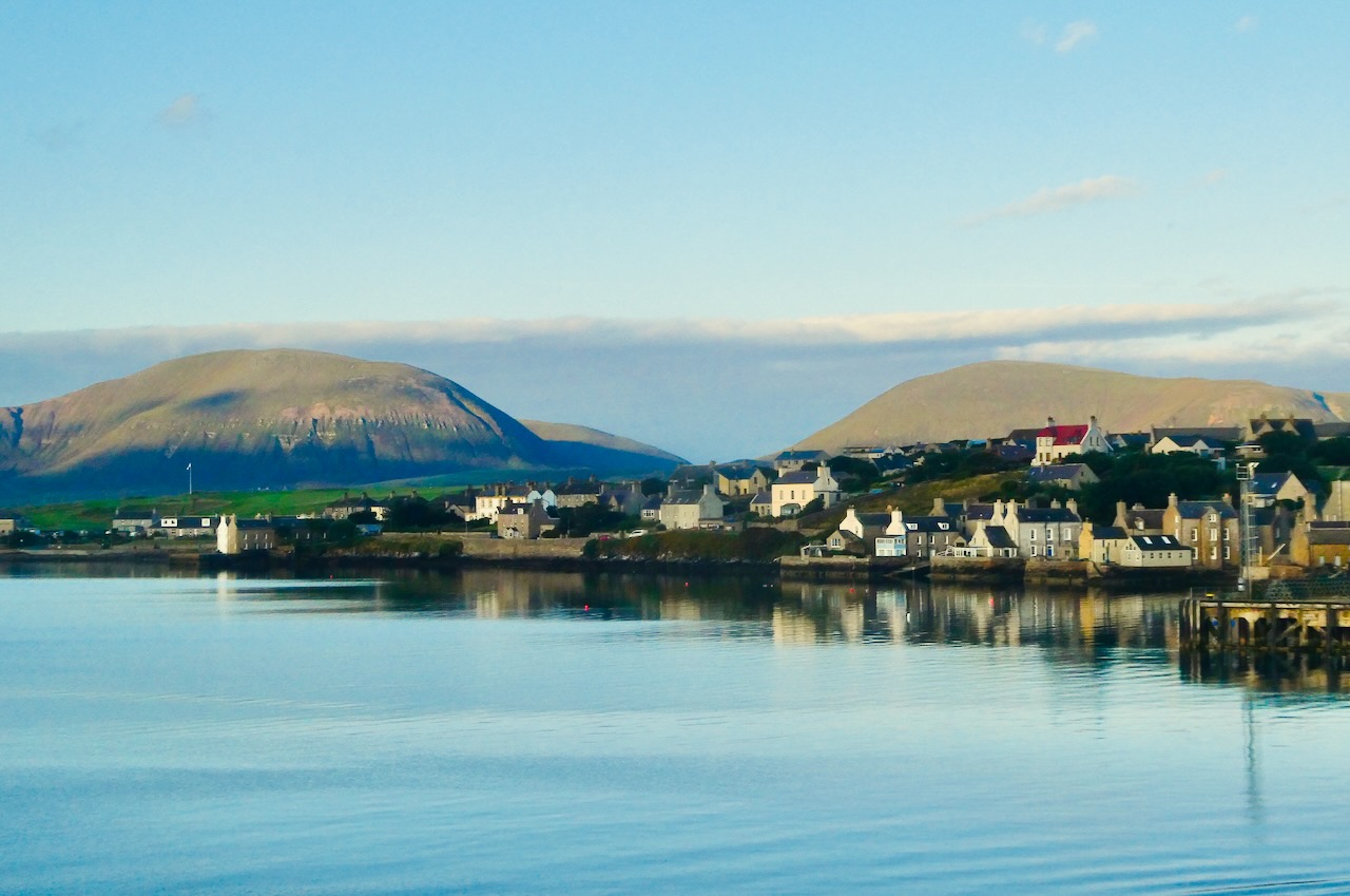
Another landscape, but why not. This was the last view seen of Orkney on this trip, as the 6.30am ferry back to Thurso turned itself around and gave its passengers one final chance to admire the photogenic qualities of Stromness, with the hills of Hoy behind. I would come back here with no qualms at all. Orkney is a great place and there should be more like it.
By a total coincidence, the picture taken ten years ago today was also timed as 6:40am. I remember this because it was another rather fine landscape, captured near the summit of Kilimanjaro on 2nd August 2015.
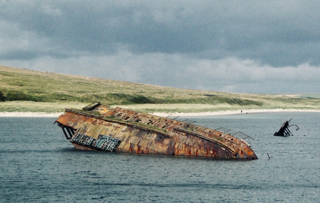
At the start of World War 2, a good portion of the British Navy was berthed in the immense natural harbour of Scapa Flow, the entrances of which were defended by a range of methods including the sinking of obsolete ships in the channels. That these defenses were inadequate was proven when a U-Boat snuck in anyway and sunk HMS Royal Oak with the loss of hundreds of lives. As a result, Churchill ordered the building of the barriers that now bear his name and block off all entrance to Scapa Flow on its western side — though, in a move typical of many public works projects, these were not in fact finished until literally four days after the war had ended. Anyway, the Barriers now act as causeways linking Orkney’s south-eastern group of islands to the Mainland, and the blockships still sit there, rusting away and playing home to the occasional lobster pot.
For those that don’t know, signs like these on British roads indicate one can drive at the ‘national speed limit’, which is no less than 60mph. Anyone doing so on this road, however, may as well presume to end up in the cemetery to which it leads, visible over there on the sea shore. Perhaps the road traffic planners of Stromness, Orkney, have a morbid sense of humour. Or perhaps my using of this photo suggests that it’s just me.
The Old Man of Hoy is around 450 feet high and probably Britain’s most well-known pillar of rock, thanks in large part to a famous televised climbing of it in the late 1960s. Plenty more people have subsequently made it to the top, including an 8-year-old, who thereby demonstrated more desire and ability to propel themselves up sheer rock faces than I ever will. But the Old Man is not some durable phenomenon. A map drawn in 1750 shows a headland here but no stack. The first known painting of it was completed in 1819 and shows him with two legs, and looking much bulkier. And when he’s seen now — as from the Scrabster to Stromness ferry this afternoon — it does look like the next really big storm will take him down. Will the Old Man last longer than the Old(ish) Man now blogging about him? We’ll take bets…. after all, if I lose, I won’t be around to collect.
Seems an appropriate shot to mark my last day here. Though, I suppose, this is a descent rather than an ascent, but never mind. Mostly, this has been an enjoyable and interesting visit, but I feel it unlikely I will ever return here.
On April 11th last year I departed on my trip to Namibia, and tonight I should have been in the air again, but instead am sitting out the year’s latest flight delay and am scheduled to depart tomorrow instead. But there are worse places to be stuck, I suppose. The surf was certainly up today, one reason why none of Ascension’s glorious beaches are considered safe places to swim. In the foreground, one of the historic ‘Turtle Ponds’, thankfully no longer used — behind, Sisters’ Peak makes its second appearance.
Now that’s a change of scene: from thatched cottages to a desert island. It’s nearly a year since my research funding award and, consequently, my chance to visit Ascension Island, were confirmed, and 73 days since I uploaded the map of this place to the blog. Zoom into that image and look at the westernmost headland of the island, where you can just about see the label ‘Tanks’: those are what you see in the distance.
St Helena doesn’t have beaches, and the tourist industry of that island may well lament this fact. But Dead Man’s Beach is a stupendous swathe of sand, and right by the main settlement, Georgetown. What a marvellously evocative name it has (though it will be explained not by the shipwreck of some 17th century pirate vessel, but because Georgetown’s cemetery lies right behind it). This is not even to mention the turtles, evidence for whom lies everywhere: but they will, hopefully, be pictured on one of the remaining eight evenings that I am scheduled to spend in the middle of the Atlantic.
In 1960 the population of Dubai was 40,000. As of today it is more than 3.7 million, and continuing to rise at around 5% a year (all figures from Wikipedia). In order to accommodate them, the city is also growing physically. What you see here is not ‘desert’, it is large amounts of sand that have been poured into the Persian Gulf — land ‘reclaimed’ because the sea is not a form of terrain that can be bought and sold. Go to Google Maps and search for “Dubai Island Villas”; you’ll find it just offshore from the Al Hamriya Port, and you’re looking at a photograph of it, as of 24th February 2025.
Captured, perhaps obviously, a minute or so after take-off from DXB this afternoon. I was sat right over a wing again and only got this because of the plane’s considerable roll to the right for a few moments, so this was the last I saw of anything except clouds for the next seven hours. That’s the end of this trip, then, but it seems reasonably likely I will be back in Dubai at some point over the next 2-3 years. It will be interesting (but perhaps also a little depressing) to see what this view might look like in 2028, say.